West

I-526 Lowcountry Corridor WEST
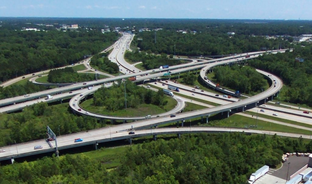
  • SCDOT currently identifies the segment of I-526 between I-26 and Virginia Avenue as the most congested segment of interstate highway in the state
  • Aims to increase capacity and improve operations at the I-526/I-26 interchange and along the mainline of I-526 from Paul Cantrell Boulevard to Virginia Avenue
  • The I-526/I-26 interchange is the major source of congestion for the corridor

About The Project

The I-526 LCC WEST project spans approximately 9.7 miles between Paul Cantrell Boulevard in West Ashley and Virginia Avenue in North Charleston. The project is a four-lane divided highway. SCDOT currently identifies the segment of I-526 between I-26 and Virginia Avenue as the most congested segment of interstate highway in the state. The remainder of the I-526 LCC WEST project, from I-26 to Paul Cantrell Boulevard, ranks among the top ten of the state’s existing most congested corridors. Forecasts show that segments of that corridor will continue to be among the state’s most congested in 2040. The interchange of I-526 and I-26 is the major source of the congestion. This is due to the high number of vehicles moving between I-26 and I-526, coupled with closely spaced interchanges with ramps that have steep grades and tight curves, and limited distances for vehicles to merge onto and off of I-526.

The I-526 and I-26 system-to-system interchange is a key interchange locally. It links downtown Charleston, Summerville, West Ashley, and Mount Pleasant. I-26 links the Charleston area with other major cities to the west like Columbia, Spartanburg, and Asheville, North Carolina, as well as with I-95, I-77, I-20, I-85, I-40, and I-81. I-526 provides the primary freeway access to two important port terminals – the North Charleston terminal and the Wando Welch terminal. Wando Welch is the busiest terminal in the region and has no direct access to rail. Not only is I-526 an important route for daily commuting traffic, it is also part of a network for transporting freight and commercial goods to and from the Port of Charleston and throughout the region.

To the west of I-26, the route crosses the Ashley River and provides a similar connection to the growing West Ashley area.

The Latest…

Purpose and Need

Purpose

The purpose of the project is to increase capacity at the I-26/I-526 interchange and along the I-526 mainline, thereby relieving traffic congestion and improving operations at the I-26/I-526 interchange and along the I-526 mainline from Paul Cantrell Boulevard to Virginia Avenue.

Need

The need for this project was identified in several different documents. The I-526/I-26 interchange is listed as the #2 project in the 2035 CHATS Long Range Transportation Plan Ranked List of Candidate Transportation Projects, the #6 project on SCDOT’s ACT 114 Interstate Capacity List, and it is listed in SCDOT’s State Transportation Improvement Plan 2017-2022. Congestion was detailed in SCDOT’s Corridor Analysis for I-526 Between North Charleston and West Ashley, and in the Interstate Plan portion of SCDOT’s 2014 Multimodal Transportation Plan, where four segments within this project corridor are listed in the top 20 most congested Interstate segments.

Alternatives

The Recommended Preferred Alternative was identified because of the lower number of relocations, fewer potential impacts to traditionally underrepresented populations, lower impacts to wetlands and streams, improved operations, and the ability to resolve a high number of existing roadway deficiencies. The Recommended Preferred Alternative includes Alternative 2A from Virginia Avenue to Rivers Avenue, Alternative 2 from Rivers Avenue to International Boulevard, and Alternative 1 from International Boulevard to Paul Cantrell Boulevard.

The maps below have been updated as of 3/25/2021.

  • Virginia Avenue to Rivers Avenue in North Charleston ENG | ESP
  • Rivers Avenue to International Boulevard, including I-526/I-26 Interchange ENG | ESP
  • International Boulevard to Mile Marker 20 in North Charleston  ENG | ESP
  • Mile Marker 20 in North Charleston to Paul Cantrell Boulevard in West Ashley ENG | ESP

Full Fly Through of the Recommended Preferred Alternative

I-26/I-526

Virginia & North Rhett Avenues

Paul Cantrell Boulevard

To compare the Recommended Preferred Alternative to the previous Reasonable Alternatives, visit the Fall 2019 I-526 LCC WEST Public Information Meeting here.

West Project Timeline