


Community Infrastructure Enhancement Plan
The Community Infrastructure Enhancement Plan is part of the overall Environmental Justice Community Mitigation Plan. A key component of the Enhancement and Preservation Pillars of the Environmental Justice Community Mitigation Plan, it is focused on providing infrastructure improvements to address bicycle and pedestrian safety, access to community centers and transit, landscaping options at neighborhood entrances, project-related stormwater improvements, bus shelters, and traffic calming measures that would be implemented as part of the project. This plan was developed based on input from the Community Advisory Council and members of the community and has been coordinated with the City of North Charleston.
 Bicycle/Pedestrian Connectivity and Safety Improvements
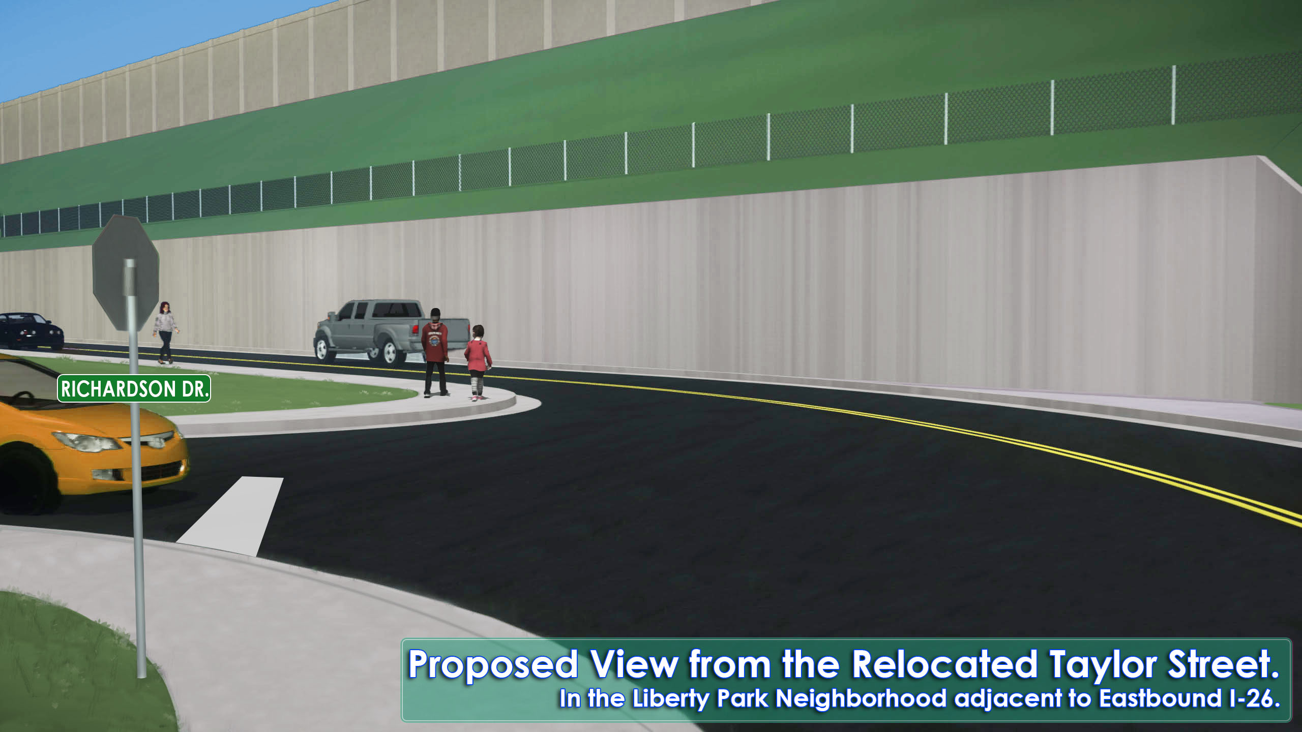
SCDOT will fund shared-use pathways to provide connectivity to the community center, pedestrian bridges to cross the railroad and Filbin Creek, improved sidewalks along Rebecca Street and Twitty Street, and new sidewalks along Russelldale Avenue, Elder Avenue, Dorothy Williams Boulevard (from the shared-use path to the existing sidewalk on James Bell Drive), and Railroad Avenue. Pedestrian safety measures will also be installed at the railroad crossing on Taylor Street. Additional pedestrian recommendations based on public comments include the extension of sidewalk on Piedmont Avenue from Iron Street to Marson Street, and pedestrian railroad crossing improvements on Taylor Street. View these proposed improvements.
 Bus Shelter Amenities
SCDOT will partner with the Charleston Area Regional Transportation Authority (CARTA) to fund bus shelter facilities at all stops along Rivers Avenue between Taylor Street and Mall Drive that border the Ferndale, Highland Terrace, Liberty Park, and Russelldale neighborhoods.
 Lighting Improvements
SCDOT will fund the installation of at least 75 pedestrian-scale lights along the proposed shared-use pathways that connect the proposed community center with the surrounding neighborhoods. Additionally, increased lighting will be considered near the Highland Terrace-Liberty Park pocket park and along the new pedestrian bridge over the railroad. Additional lighting recommendations, based on survey feedback, include the addition of streetlights along Rebecca Street, Elder Avenue, Taylor Street, and Piedmont Avenue. View these proposed improvements.
 Traffic Calming Measures
SCDOT will fund and install traffic calming measures on the following streets: Taylor Street, James Bell Drive, Dorothy Williams Boulevard, Rebecca Street, Russelldale Avenue, Piedmont Avenue, and Railroad Avenue. Additional traffic calming recommendations based on public comments include the addition of speed humps on Taylor Street in Highland Terrace and on Elder Avenue south of James Bell Drive, relocating proposed speed humps further south on Piedmont Avenue and Railroad Avenue, and implementing crosswalks at the locations identified by survey participants after further investigation of feasibility. Possible construction of speed humps along Piedmont Avenue and Railroad Avenue will be determined following a speed study to determine if the speed limit can be reduced to 25 miles per hour. More detailed traffic studies will be required in the design of these improvements and changes in the actual locations of traffic calming measures may be revised based on more detailed information. View these proposed improvements.
 Stormwater Infrastructure Improvements
SCDOT will fund and install stormwater improvement measures on sections of the following streets: Harper Street, Willis Drive, Elder Avenue, Taylor Street, James Bell Drive, Rebecca Street, Piedmont Avenue, and Railroad Avenue. Potential drainage improvements will also be investigated along Target Street and in conjunction with locations recommended for pedestrian improvements. View these proposed improvements.
 Aesthetics and Landscaping Improvements
SCDOT will fund and implement plantings/seating/lighting at neighborhood entrances on Piedmont Drive (Ferndale), Fuller Street (Ferndale), Taylor Street (Highland Terrace/Liberty Park), and Rebecca Street (Russelldale) to help reinforce neighborhood identities. In addition, there will be an opportunity for public art at shared-use path trailheads, pocket parks, and the community center. Educational and wayfinding signs will also be implemented.
View the materials from the Community Infrastructure Enhancement Plan Open House held on March 6, 2021:”
Questions? Call or text the Community Office at 843.258.1135
Community Centers
How would the project impact the Russelldale and Highland Terrace-Liberty Park Community Centers?
The proposed improvements to I-526 and I-26 as part of the I-526 LCC WEST would require the removal of the Russelldale Community Center and result in impacts to the Highland Terrace-Liberty Park Community Center. To address the potential impacts to both facilities, SCDOT will fund the construction of replacement recreational facilities and associated infrastructure to mitigate project impacts. SCDOT is in the process of acquiring property and would provide funding to the City of North Charleston to construct one large, modern, centrally located community center complex with expanded programs and operating hours in Liberty Park and two pocket parks; one adjacent to Highland Terrace and the other in Russelldale. The Russelldale pocket park location is preliminary and SCDOT is committed to continuing to identify additional locations within Russelldale and reviewing the options with community members. Additional details of the amenities to be included in the community center and the pocket parks will be included in an inter-governmental agreement between SCDOT and the City of North Charleston. Construction of the new, centrally located community center and the pocket parks will be completed prior to the project construction impacting the existing community centers.
Take a look at these potential, new recreational amenities

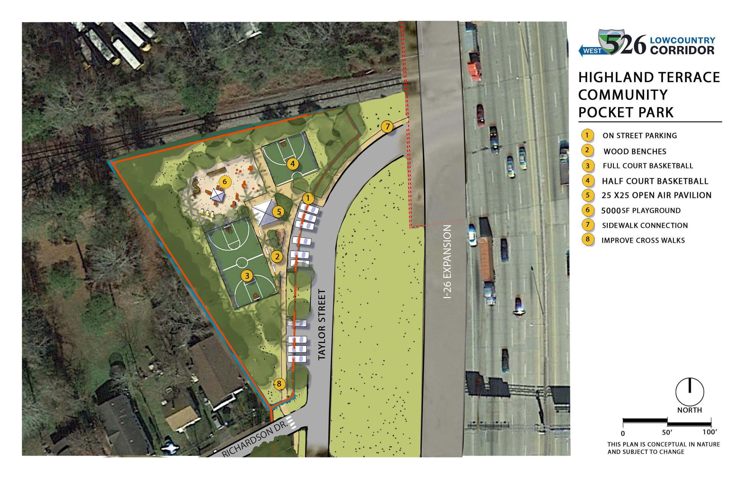

Some of the recreational amenities will include, but are not limited to:
- Classrooms designed for flexibility, which include moveable panel divider walls allowing room size to be modified to meet program needs,
- Basketball courts,
- Facility approaches to be well-lit, and meet design requirements to provide safe lighting for center visitors,
- Covered shelters with grills,
- Walkways, common spaces to be user-friendly and defined by vegetation or other natural definitions; fencing should not be first choice,
- Wayfinder/directional signs to help guide residents to new facilities,
- Facility and pocket park approaches designed with pedestrian facilities, crosswalks, and traffic calming measures such as speed humps,
- Emergency generators to enable the community center to be used as a food and supply distribution center during emergencies and/or inclement weather,
- Facility to include shared use path to provide recreational opportunities for walking/biking and connectivity to North Charleston’s proposed Greenway system,
- Satellite parking on Dorothy Williams Boulevard and Margaret Drive, adjacent to the shared use paths, to provide additional access points for residents driving to the community center,
- Audio/visual equipment,
- Artwork and visual displays based on recommendations from the Community History Preservation Program, and,
- Multiple pedestrian access points to the community center.
Mitigation Barriers
UPDATED: Mitigation barriers are walls constructed along a highway to protect sensitive land-uses, such as homes, from impacts associated with transportation projects. SCDOT will construct mitigation barriers along the eastbound and westbound sides of I-26 and I-526 and Remount Road interchanges to benefit the Highland Terrace and Liberty Park communities and the westbound side of I-526 between the Rivers Avenue and I-26 interchanges to benefit the residents of the Liberty Park community. SCDOT will construct mitigation barriers along the eastbound side of I-526 from the I-26 interchange to east of the CSX railroad tracks to benefit the residents of the Russelldale and Ferndale communities. SCDOT will construct a mitigation barrier along the eastbound side of I-526 and the eastbound exit ramp at the Montague Interchange to benefit the west side of the Camps community.
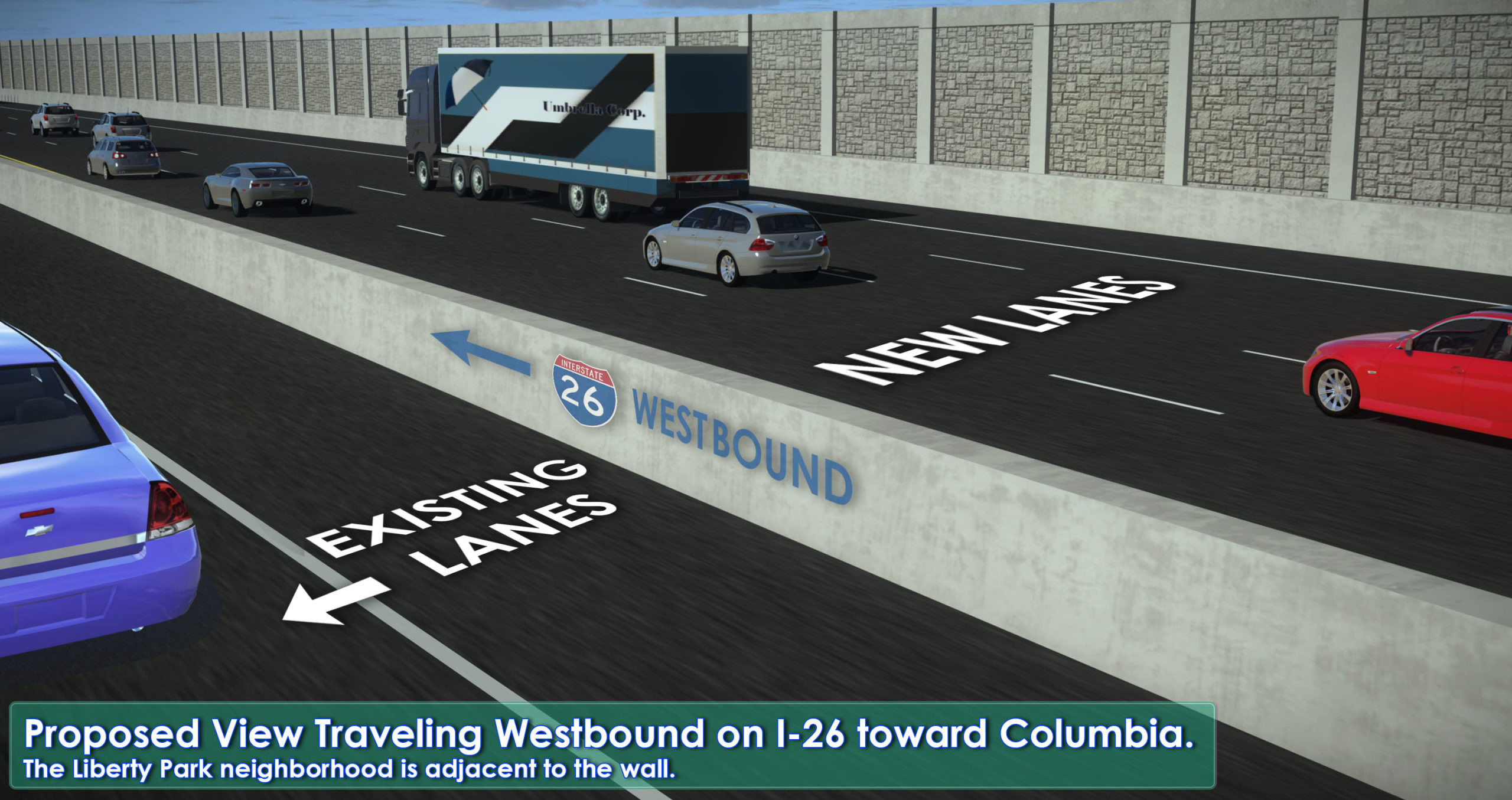
View Image
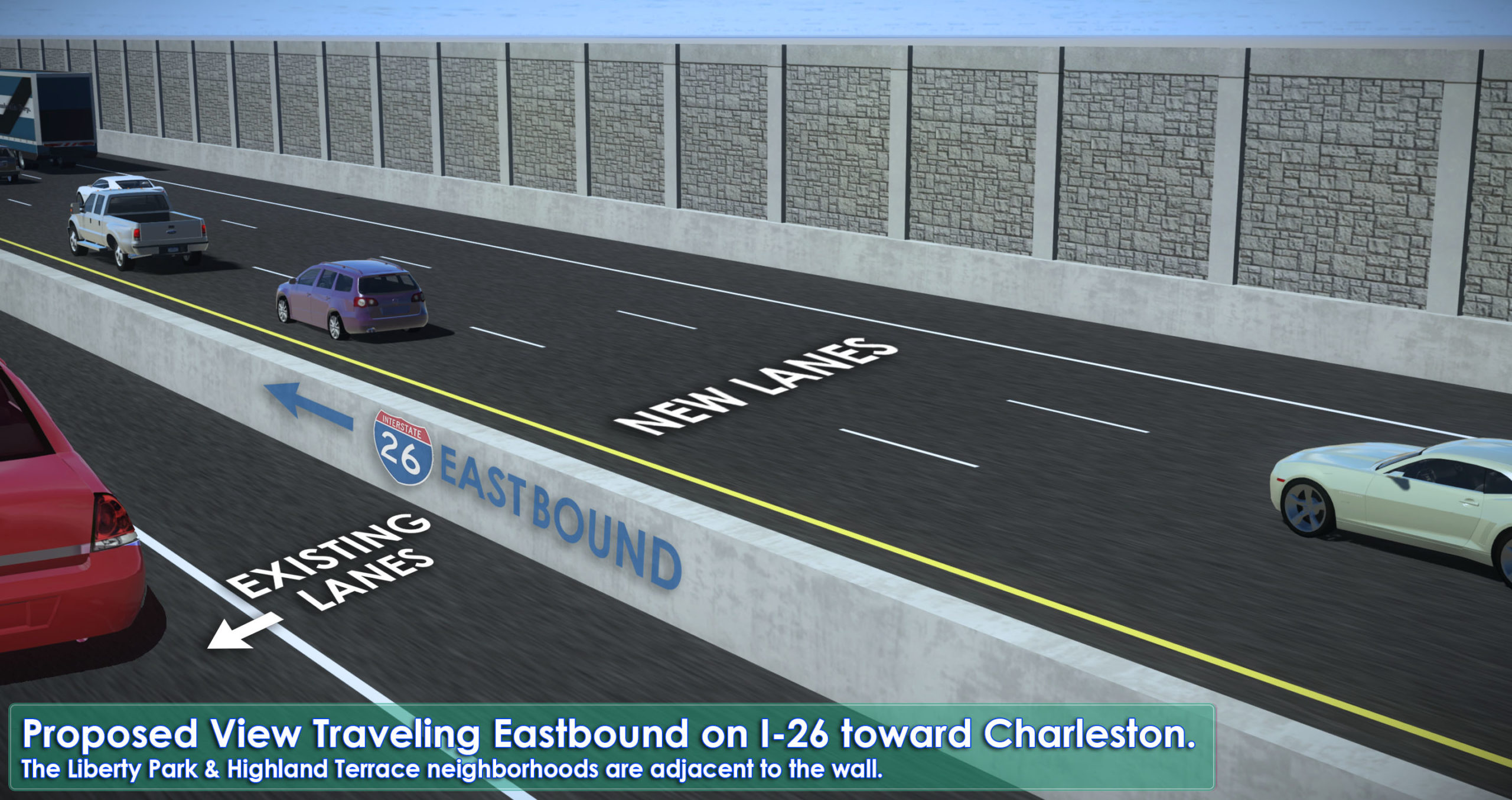
View Image
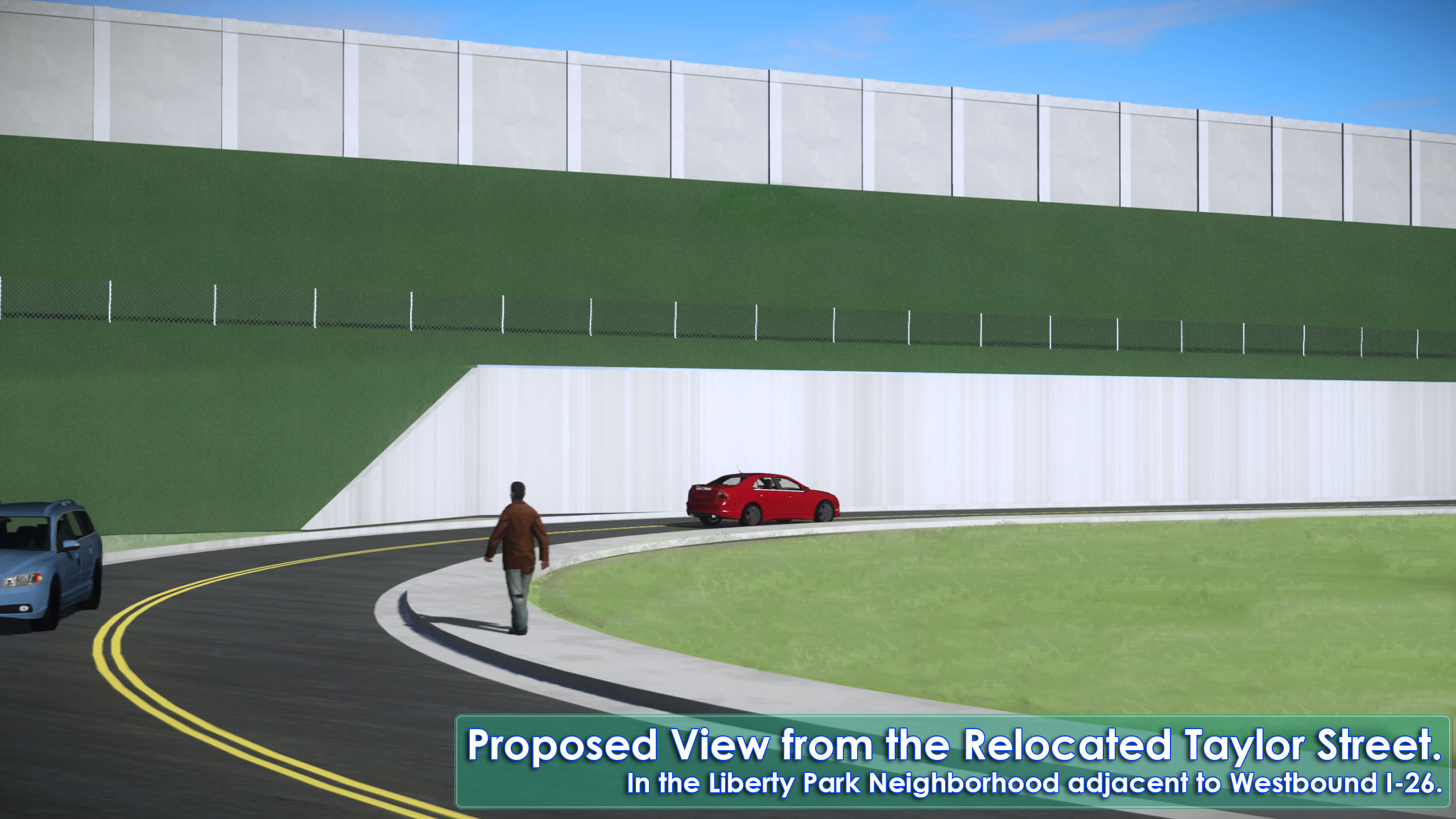
View Image
View Image
NEW! Community Air Quality Monitoring
Air quality sensors will be installed to detect fine particles of pollutants (Particulate Matter 2.5) in Ferndale, Highland Terrace, Liberty Park and Russelldale. The sensors will provide real-time data online to these communities during construction, and SCDOT will develop a response plan for elevated levels.