
General FAQs
Who should I contact if I have questions about the project or the process?
Feel free to contact the project team if you have any questions or concerns by calling/texting our hotline at 843.258.1135 or emailing us at info@526LowcountryCorridor.com. You can also visit us at the Community Office at 5627 Rivers Ave., North Charleston in Gas Lite Square. See office hours here.
What is the current status of the I-526 LCC EAST PEL study?
SCDOT has concluded the Planning & Environmental Linkages (PEL) Study for the I-526 Lowcountry Corridor EAST (I-526 LCC EAST) which examines existing and projected transportation issues within the corridor based on input you provided. An initial public meeting was held in 2020 to help define the needs of the corridor. A second public meeting was held in late 2021 to present the analysis completed to-date and the reasonable alternatives, and to ask for additional feedback. Public and stakeholder comments on the reasonable alternatives indicated a desire to look at ways to reduce impacts to the residential areas north of I-526 between the Wando River and Long Point Road. As a result of public comments, a new alternative, Alternative 3A, was developed by modifying Alternative 3. Alternative 3A would retain the compatible connection with the I-526 LCC WEST project while reducing the project footprint resulting in fewer impacts to the community and natural environment as compared to Alternative 3. View Alternative 3A here. As a result of this study, SCDOT has funded the I-526 @ Long Point Road Interchange Improvements project to address congestion concerns in this area. View here
If I signed in at the meeting will I be kept informed about future project meetings and milestones?
Not necessarily. Due to anti-spamming laws, SCDOT does not automatically add attendees to our email update list unless there was a specific question that asked if you would like to receive updates. While we may occasionally mail documents through USPS, we encourage you to sign up for updates on our Stay Informed page to receive all updates.
For project updates follow us at facebook/@526Corridor or on Twitter @526Corridor.
What is going to be done about the flooding that occurs now and will anything be done to keep it from getting worse?
The project team will evaluate stormwater management performance of the existing corridor and include appropriate improvements as part of the recommended preferred alternative for the project.
What prompted the I-526 LCC EAST study?
This segment of I-526 LCC EAST has been identified by the South Carolina Department of Transportation (SCDOT) as one of South Carolina’s more congested segments of interstate. High traffic volumes create considerable congestion during the weekday morning and afternoon peak commuting periods. Several factors are expected to compound this congestion, including the current trend of regional population growth, industrial expansion along the corridor specifically at the Charleston International Airport, and the opening of a new container terminal by the South Carolina Ports Authority.
Congestion increases the cost of travel, reduces productivity and competitiveness for our industries, and adversely affects the environment. Finding effective solutions for this corridor that are consistent with the needs of the community has become a statewide priority.
Will I get to vote on which alternative I want to move forward?
The I-526 LCC EAST is a planning-level study that provides recommended projects and costs for consideration in SCDOT’s future statewide transportation plans. This process does not include a public vote, however all comments received are reviewed and considered before the final report is published. The support from the community for certain improvements does assist SCDOT in developing projects that balance the transportation needs with the preferences of the community and the natural environment.
Why were improvements not suggested at all interchanges and only at Long Point Road?
Initially, the project purpose was focused on improving travel time reliability on the mainline only with only limited modifications at interchanges. Based on the current reasonable alternatives, the project team established that some level of improvement and reconstruction would be needed at all interchanges to accommodate the widening of the interstate mainline. Based on the studies done to date, it is anticipated that the interchange type at Clements Ferry Road would stay the same; however, ramps would have to be relocated to make room for the widened mainline. Most of the Daniel Island interchange could likely be retained; however, some work would be needed at the interstate tie-ins. The Long Point Road Interchange stands out at this phase of analysis, in that, it appears a different type of interchange may be needed at Long Point Road to address current and projected deficiencies.
What happens next after the PEL study?
The PEL study provided a collection of possible projects and estimated costs for consideration as part of SCDOT’s future statewide transportation plans. Recommendations are also available for other project partners to consider for implementation in local efforts. If and when projects are funded, they would advance to the environmental phase, NEPA. During that process, the range of alternatives would be further refined and narrowed down to a recommended preferred alternative based on additional studies, engineering design, and public input. This is when noise and right-of-way impacts will be analyzed in detail. The first funded project that would be carried forward from the PEL study into NEPA is the I-526 @ Long Point Road Interchange Improvements project.
Which other types of concepts were evaluated that didn’t involve widening or building a new road?
The project team looked at and continues to evaluate a series of strategies that focus on operational improvements without the need for expansion, known as Transportation Systems Management and Operations (TSMO). Because of the physical constraints of the existing bridges, shoulders, and roadway, it would not be possible to retrofit the corridor with enough TSMO strategies to fully address the capacity needs of the corridor. While TSMO strategies would not provide enough lane capacity improvement or improvement to travel time reliability to work as stand-alone alternatives, they could help achieve an acceptable level of improvement in operations in combination with future widening. We will continue to evaluate these options moving forward and look for ways that they can be included as part of an expansion project. Learn more.
Are truck-only lanes being evaluated as part of the I-526 LCC EAST?
Adding a travel lane for trucks only was evaluated as a Transportation Systems Management and Operations (TSMO) strategy. To evaluate the potential performance of TSMO strategies at this planning-level analysis, a combination of the I-26 Corridor Management Plan and other case studies were used to report on the anticipated benefit of these strategies. The project team found that a dedicated truck lane would not meet the purpose and need of this corridor without regional implementation, and therefore, was not carried forward as a reasonable alternative. Should regional efforts make dedicated truck lanes a priority, this action would be incorporated into NEPA studies. Restricting trucks to the right-most lane remains an option.
How do you determine the height of the Don Holt and Wando bridges?
The height of the proposed bridges would be established in coordination with the U.S. Coast Guard during the federal environmental (NEPA) process and would include a navigational study of the channel. During the navigation study, navigational activities supported by the waterways surrounding the proposed project would be identified through vessel traffic data and waterway stakeholder surveys. The navigation study would help identify potential navigational impacts of the proposed project to determine the appropriate vertical and horizontal bridge clearances. If there are users of the waterway with a need for a higher vertical clearance, that would be taken into consideration during the navigational study. The displayed height of 65’ for the Wando bridges during the 2021 public information meeting is the minimum height allowed by the U.S. Coast Guard and was used for conceptual purposes. However, the actual proposed height of the bridge would be determined by the U.S. Coast Guard during the NEPA process. Our intent in showing a lowered height for the Wando and a raised height for the Don Holt at this meeting was to get feedback from those who regularly use the waterway. Additional feedback from marinas and other commercial and recreational users would be sought in the future during a navigational study to provide a more complete picture of the actual uses of the waterways.
Can’t SCDOT just restripe the lanes over the Don Holt and Wando bridges and mainline to widen to three lanes?
SCDOT studied options to restripe I-526, but a safety analysis predicted an increase in crashes due to the loss of existing shoulders. Why are shoulders important for your safety? Shoulders allow drivers to pull out of traffic more safely after crashes or breakdowns and provide an area for drivers to move to avoid crashes or recover control of their vehicle.
Are any new alternatives being proposed as a result of public comments from the 2021 public meetings?
Public and stakeholder comments on the reasonable alternatives indicated a desire to look at ways to reduce impacts to the residential areas north of I-526 between the Wando River and Long Point Road. Alternative 3 included the replacement and symmetrical expansion for both the Don Holt bridge and the Wando bridges in order to create a consistent tie into the I-526 Lowcountry Corridor WEST (LCC WEST) project which includes symmetrical widening. In addition, Alternative 3 would accommodate maintenance of traffic on the corridor during the construction process as the current facility would stay in use throughout the construction process.
This alternative was eliminated because it had the largest right-of-way footprint, resulting in the greatest number of community and natural resource impacts in addition to the impact of an African-American cemetery.
Alternative 3A was subsequently developed to reduce the size of the footprint between the Wando River and Long Point Road. This alternative would replace the Wando River bridges in stages by first constructing two new parallel two-lane bridges, then removing the existing bridges and widening the newly built bridges to four lanes. This modified alternative would retain the compatible connection with the I-526 LCC WEST project while reducing the project footprint resulting in fewer impacts to the community and natural environment as compared to Alternative 3.
Noise FAQs
What is SCDOT doing to help reduce noise in the I-526 LCC EAST study area?
The EAST PEL study is a higher-level planning study, and a detailed noise analysis would be done in the next phase of the project development (NEPA). SCDOT understands noise impacts are an important concern for residents and will make it a top concern as the project further develops. SCDOT has policies in place that outline how it implements the Federal Highway Administration noise regulations and standards for federal aid projects and/or projects subject to Federal Highway Administration approval.
Why does SCDOT perform vegetative maintenance?
SCDOT cuts and maintains vegetation in Clear Zones to improve safety. Clear Zones along pavement edges help motorists stay safe when vehicles leave the road, providing a clear area for vehicles to recover or come to a stop safely if they leave the roadway. This is extremely important as the majority of fatal accidents in South Carolina involve contact with a fix object. Additionally, vegetative maintenance helps improve drainage and allows us to better access the ditch line and fencing for maintenance.
How is traffic noise evaluated?
For the first step in the process, SCDOT experts go to homes, churches, businesses, or other places that may be affected by a proposed highway project and use special equipment to monitor existing noise.
Next, complex computer modeling is used to predict expected noise changes at these locations once the road is built and traffic increases.
Then, it must be determined which noise-sensitive locations were permitted before the Date of Public Knowledge and, therefore, are eligible for noise reduction.
If the anticipated noise increase is MORE than the level defined by SCDOT policy, we begin to consider possible ways to reduce the noise, such as with noise walls and earth berms, at all eligible locations.
When are noise walls considered?
Whenever a highway project uses federal funds and meets the Federal Highway Administration’s (FHWA’s) criteria of a Type I project, the potential for increased traffic noise and how to reduce it must be evaluated. For all Type I projects where traffic noise impacts are predicted, noise abatement (typically in the form of noise walls) must be considered.
Potential traffic noise increases are evaluated for any building permitted before the “Date of Public Knowledge.”
What is the “Date of Public Knowledge”?
This is the date that the public (and local government) is notified of the future path of the road and is the date of approval of the Categorical Exclusion (CE), the Finding of No Significant Impact (FONSI), or the Record of Decision (ROD).
Are there alternatives to noise walls?
Other options may also help reduce traffic noise. Some of these may be provided by SCDOT, and others are alternatives that might be considered by private developers or homeowners.
- Land use design – if homes are set back from the road or are separated from the road by other development, the noise levels may be lower.
- Noise berm (earth or other materials) and combination berm/wall systems
- Types of vehicles/speed limits – noise can be reduced with lower speed limits and truck restrictions on a road. However, reducing the speed limit below the appropriate speed based on the design will have only a moderate effect on traffic noise and may actually increase the number of accidents on the roadway
- Building insulation – noise insulation in buildings, such as replacing doors and windows or adding insulation to walls and attics
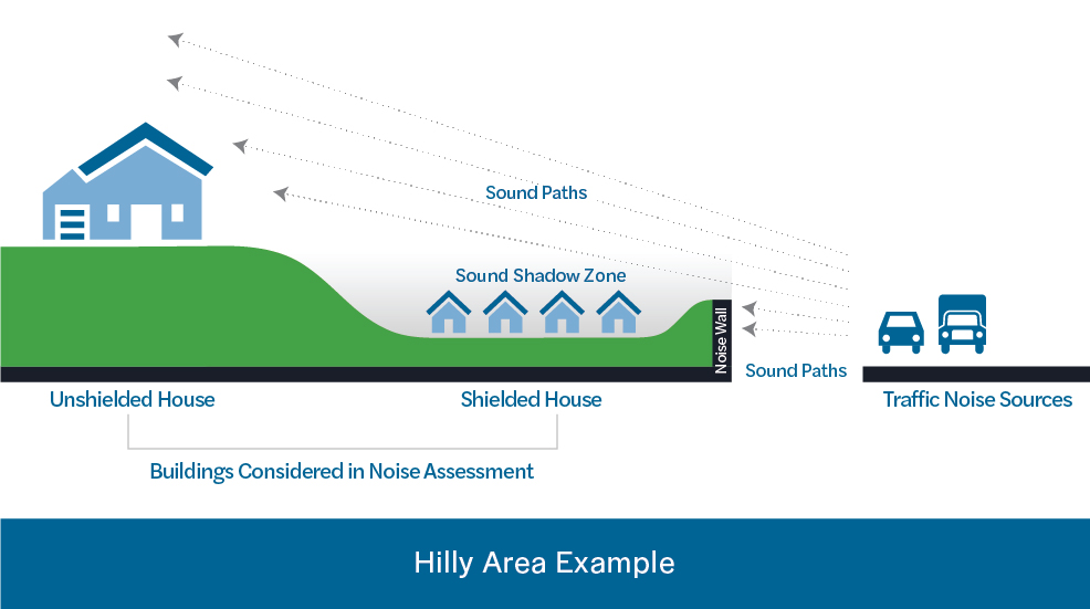
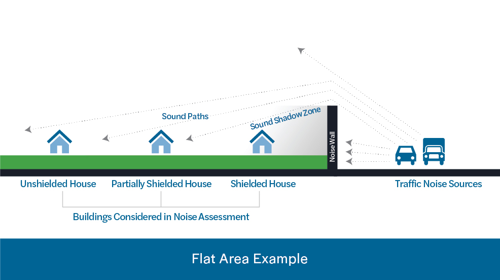
When do noise walls work?
Sounds travels very much like water or light. It follows the easiest path over, under, and around things in its path. The farther away from the source of the sound, the lower the noise.
Noise walls do not work if the source of the noise can be seen. The noise will simply travel through that opening much like water will flow through a crack in a dam. If a building is located higher than a noise wall, the noise will flow over the wall to the building.
The graphic shows two examples of noise walls located between buildings and a road. In both cases, the wall will shield one of the houses but will not shield them all.
Noise walls do not completely eliminate all noise.
How does SCDOT decide which communities get noise walls and which do not?
Once SCDOT has completed the detailed noise analysis during the National Environmental Policy Act (NEPA) phase of the project (environmental process), and potential noise impacts are identified, the following questions will be considered:
- What are the current conditions? The project team will collect data and establish a baseline for existing conditions currently experienced in the corridor. All project alternatives will be compared with the amount of noise currently experienced.
- What are the projected future conditions? Noise abatement is based upon projected traffic volumes a future year, typically 20-30 years after construction is anticipated to begin. This is done to ensure that additional traffic volume, which could generate additional noise impacts, will be considered.
- Would a noise wall reduce the noise enough to justify its construction? Sometimes, a noise wall will not reduce the noise enough to be considered reasonable and/or feasible.
- Is a noise wall technically feasible? Every road is different. Many factors are considered such as topography, safety, drainage, utilities, maintenance of the wall, and whether driveways and side road access will be impacted.
- How many people would hear a difference in the noise? Is that number high enough to justify the cost? Sometimes, the cost is too high to build a wall when compared to the benefits received.
- Does a simple majority of property owners and tenants who receive a predicted noise level reduction due to the construction of a noise wall actually want the wall? Public preference for or against a wall is obtained through a balloting process.
What assurances are there that noise impacts will be considered and that noise walls will be built where needed?
Federal regulations require SCDOT to conduct noise studies and consider the impacts of a highway expansion project on nearby residents when a project is developed with federal funds. SCDOT’s Noise Abatement Policy describes the process that SCDOT uses to determine the reasonableness and feasibility of constructing noise walls.
To learn more about how SCDOT considers noise impacts during the project development process, we invite you to watch the “Highway Traffic Noise” educational video.
Why was a noise barrier not constructed on Interstate 26 as part of the 2008 widening and interchange improvements at Remount and Aviation?
The construction of noise barriers on federally funded projects depends upon a number of factors including engineering feasibility, sound level reduction, cost, and public input. The noise analysis for the 2008 project determined that a noise barrier was not reasonable due to prohibitive costs. However, SCDOT would be required to evaluate noise impacts and assess the need for noise barriers if I-26 is widened in the future.
Why are more details on noise not available?
As a planning study, we are currently defining the transportation challenges and range of possible alternatives. As the project advances into the environmental process, these concepts will be further refined. Having a refined design would allow us to model the potential noise more accurately and explore various noise reduction strategies.
Right-of-way Acquisition FAQs
What is the process for determining the project footprint or what homes and businesses the project will impact?
SCDOT roadway and bridge improvement projects are planned and developed through an extensive environmental review process, in accordance with the National Environmental Policy Act (NEPA). During this environmental review process, SCDOT performs environmental and community surveys and evaluates all the potential project alternatives that could be considered to meet the purpose and need of the highway improvements. SCDOT seeks to find the project alternative that strikes the best balance between meeting the needs of the highway and minimizing the impacts to the natural and human environments.
Community impacts, such as right-of-way impacts and property owner relocations, are considered as a part of the NEPA process. The public and potential impacted communities will be engaged throughout the NEPA process to gather input on the proposed project alternatives. This graphic demonstrates the general project development process for this type of project.
What is Right-of-way (ROW) and what law do we follow when buying ROW?
When we (SCDOT) build or improve roads and bridges, we often have to acquire property, known as right-of-way, or ROW. We have uniform practices for conducting property acquisitions, providing relocation assistance, and preparing appraisals. We follow the Uniform Relocation Assistance & Real Property Acquisitions Policies Act of 1970, which protects property owners’ rights and ensures that everyone is treated fairly and equitably during property acquisitions. If you have specific questions about the ROW process or relocation benefits, please give us a call or come by the Community Office to schedule an appointment with our ROW specialists.
Additional resources are available on the SCDOT and FHWA website at the following links:
• Your Rights and Benefits as a Displaced Person under the Federal Relocation Assistance Program
• Introduction to Right-of-Way Requirements and the Uniform Act
The construction of noise barriers on federally funded projects depends upon a number of factors including engineering feasibility, sound level reduction, cost, and public input. SCDOT would be required to evaluate noise impacts and assess the need for noise barriers if I-26 is widened in the future.
When does the ROW process start, and how does it work?
The official right-of-way (ROW) acquisition process does not typically start until the NEPA process is completed and a NEPA decision has been issued by the Federal Highway Administration (FHWA), who is overseeing the project. If a build alternative is selected, SCDOT will develop the final ROW plans for the project. Once ROW plans are finalized, the plans will be provided to the SCDOT ROW agents and ROW acquisition activities would begin in the steps outlined below.
ROW agents will perform research on the properties that need to be acquired for the project to confirm ownership and secure property records.
Next, the agent will contact the property owners individually to discuss the project, explain the ROW acquisition process, gather information about the property, and gather information to determine the relocation benefits eligibility (if applicable).
The agent will prepare a cost estimate (for properties valued at less than $20,000) or order property appraisals in order to establish the fair market value of the property. Real estate appraisals are performed by licensed South Carolina appraisers who are certified general real estate appraisers. The property owner will be contacted by the real estate appraiser in order for the property to be inspected. The property owner will be given the opportunity to be present during inspection of the property and be able provide information concerning the property or recent property sales in the area to the appraiser.
Once the appraisal is completed and approved, then the agent will prepare an offer and relocation benefits package (if applicable) that will be presented to the property owner. The agent and the property owner will negotiate based on a written offer that will be provided to the property owner.
While this is the normal process, FHWA does allow some early ROW acquisition activities under certain special circumstances. SCDOT must prepare a detailed proposal and seek FHWA approval for any early or advance ROW activities. These advance ROW acquisitions are usually limited to those properties that would be impacted by the project in the case of any of the alternatives being considered.
What are the options to the exercise of eminent domain through condemnation? What other things occur before SCDOT would take my house this way?
In the event SCDOT and the property owner are unable to negotiate a settlement, the South Carolina Eminent Domain Procedure Act provides a uniform procedure for condemnation of property for public use. The purpose of the condemnation process is to establish just compensation when two parties cannot agree on what fair market value should be for a particular property. There will be opportunities through this process to mediate a settlement before going to a jury trial.
What if equivalent housing is not available?
On highway projects in South Carolina where people will be relocated, a survey is made by SCDOT of the families to be moved and the housing available in the area. The right-of-way agents working on the project will personally interview you if you are to be relocated, and determine your relocation needs and preferences. You will be provided current and continuing information on the availability, purchase prices, and rental costs of comparable replacement housing. You are not required to choose the comparable replacement housing presented by the agent and can pick other housing units or move to other locations at your discretion. You cannot be required to move unless at least one comparable replacement housing is made available by SCDOT. Comparable replacement housing must meet the following criteria:
- Decent, safe, and sanitary.
- Functionally equivalent to the acquired house with particular attention to the number of rooms and living space.
- Large enough to accommodate the occupants.
- Located in an area that is not subject to reasonable adverse environmental conditions, and not in an area that is generally less desirable that the acquired house.
- Reasonably accessible to the person’s place of employment.
- Located on a site that is typical in size for residential developments with normal site improvements including customary landscaping.
- Currently available on the market.
If equivalently priced housing is not available and the new housing costs more, who pays the difference?
The right-of-way agent will inform you in writing of the specific comparable replacement housing and the sales prices or rent used as the basis for establishing the upper limit of the replacement housing payment and the basis for that determination. So you will be aware of the amount of the replacement housing payment to which you may be entitled. If the comparable replacement housing available on the market are priced higher (property appraised value or rent), the homeowner may be eligible for supplemental benefits for a period of time to cover this price differential, including increased mortgage interests costs and all eligible incidental expenses (such as closing costs).
What about the increased property tax associated with a more expensive home? Is there a mechanism for help or relief?
The comparable replacement housing offered to the property owner should be within the property owner’s financial means, meaning the monthly payments and estimated average utility costs at the replacement housing does not significantly exceed their current payments. The property owner may be eligible for supplemental benefits or payments to cover price differentials in the purchase price or rent. However, this supplemental payment does not address the increased property taxes on the property. SCDOT’s agent will inform the property owner of the estimated property taxes of any comparable replacement housing offered and ensure that the property owner is aware of this difference prior to any decisions regarding the replacement property.
If my house is to be taken who pays to move me? What costs are covered/not covered?
Any individual, family, renter or business that will be displaced as a part of the project may be eligible for benefits under the SCDOT Relocation Assistance Program. The benefits package may vary based on the type of household and personal situation. The right-of-way agent will meet with you to determine your relocation needs and preferences and explain the relocation payments and other assistance for which you may be eligible. These benefits may include assistance in finding comparable replacement housing, housing inspections, transportation to view housing options, advisory services, moving expenses, and supplemental payments for price differentials in comparable housing, incidental expenses, and/or rent supplements. SCDOT has right-of-way relocation specialists available to answer your questions and provide guidance based on your specific situation. Please contact Joy Riley, the SCDOT Project Manager, for additional information.
What if I rent, not own?
All displaced persons, whether a property owner or a tenant, may be eligible for relocation assistance. The assistance available to tenants may include agent assistance in finding comparable rental replacement housing, transportation to view housing options if needed, advisory services, actual moving expenses, and supplemental rent payments. If a renter wishes to consider property ownership as part of the relocation assistance program, then the benefits payment could be used by a displaced person for a down payment and closing costs on a replacement house if desired. The displaced tenant should tell the agent their preference to consider home ownership after the relocation offer has been made so the agent can advise the tenant on this potential opportunity.
What if I am an owner, but not a resident?
Property owners will be contacted during the initial right-of-way acquisitions and provided with an offer of real estate purchase based on the fair market value of the property and any improvements on the property being purchased. If any housing on the property is vacant at the time of purchase, then relocation entitlement would be for personal property moves only. No replacement housing payment would be applicable to the property owner who does not reside on the property and is not being required to relocate as a result of the project, any tenants that have previously vacated the property prior to initiation of negotiations (written offer), nor any person who occupies the property after SCDOT acquires title to the property.
What if I am a business owner and you are impacting my business?
Businesses that are impacted by a highway project may also eligible for relocation benefits. Business owners may be eligible for moving expenses, relocation assistance for finding a new business location, searching expenses, and business re-establishment expenses. Right-of-way agents will work with each impacted business to identify their benefits eligibility and assist them in understanding their benefits package.
Why can’t ROW for properties that would be within the 75-foot area currently needed for maintenance that was mentioned at the meeting be acquired now?
SCDOT is currently performing detailed right-of-way relocation studies in the potentially impacted communities in order to identify potential opportunities to work with the community to advance some early right-of-way (ROW) acquisitions and/or relocations. As SCDOT moves forward in refining the project alternatives, we will determine if there are properties that would be impacted with all available alternatives. At that time, we will explore with our federal project partners, FHWA, the potential for advanced ROW activities and seek their approval for any proposals for advanced acquisitions.
What is the capital gains exposure for homeowners that sell their homes?
SCDOT recommends that the homeowner consults with their accountant or tax preparer.
Can you provide an example of projects in recent years, where relocations were necessary, and can we get some information about how that turned out for those affected?
During the past 12-15 years, there have been no formal relocation appeals or any formal complaints filed on any SCDOT project with relocation assistance.
Why are more details on right-of-way impacts not available? When will we hear more?
As a planning study, we only have design concepts with conservatively established right-of-way limits. When the project advances into the federal environmental review process, NEPA, these concepts will be further refined, and more detailed designs will be developed. More detailed designs will help to better determine, avoid, and minimize possible right-of-way impacts. This will be shared with the public and feedback would be gathered before any final decisions are made.
How much right-of-way is needed? Is it not possible to just widen to the median instead?
Community impacts, such as right-of-way impacts and property owner relocations, are considered as a part of the NEPA process. The conceptual alignments for potential future improvements, including proposed right-of-way, can be viewed on this mapping tool.
The public and potentially impacted communities will be engaged throughout the NEPA process to gather input on the proposed project alternatives. SCDOT will work to minimize impacts to adjacent homes and businesses as the designs are developed.
We do include options that widen to the middle. However, in all cases, some amount of widening is still needed to the outside.
When will the right-of-way acquisition process begin? What if equivalently priced housing is not available?
The official right-of-way acquisition process does not typically start until the NEPA process is completed and a NEPA decision has been issued by the Federal Highway Administration (FHWA), who oversees the project. When projects are funded from the PEL Study, then schedules will be developed and provided to the community. If a build alternative were selected, SCDOT would develop the final right-of-way plans for the project. Once right-of-way plans are finalized, the plans would be provided to the SCDOT right-of-way agents and acquisition activities would begin in the steps outlined below.
SCDOT follows the Uniform Relocation Assistance and Real Property Acquisition Policies Act of 1970, as amended. On highway projects in South Carolina that require relocations, SCDOT makes a survey of the residential households to be relocated and the available housing in the area. The right-of-way agent informs you in writing of the specific comparable replacement housing, the sales prices or rent used as the basis for establishing the upper limit of the replacement housing payment, and the basis for that determination. If the comparable replacement housing available on the market is priced higher (property appraised value or rent), the homeowner may be eligible for supplemental benefits for a period of time to cover this price differential, including increased mortgage interest costs and eligible incidental expenses (such as closing costs).
For more information on the right-of-way process, visit the SCDOT website.